
Peter Nye
Eagle Home Page
Challenge Questions

Today's News

Spring's Journey North

Report Your Sightings

Teacher's Manual

Search Journey North
return to:

.
 A/CPB
A/CPB


Weather and Migration
When Did Eagle #F44 Fly?
Analysis by Glen Schuster
satlab@ns.computer.net
|
|
|
Eagle F44 in Yellow |

Let's and analyze the weather conditions to figure out which day F44 may have moved.
First let's look at the weather on the 4th - 7th. Which days might have been the best for traveling?
April 5th
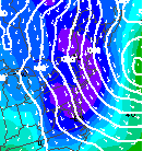 This
map shows the air flow above the surface on April 5th. The arrows show the direction the winds a few thousand feet
above the earth's surface are blowing-- a headwind. (The circle off the Atlantic coast is a LOW pressure system,
and winds blow counterclockwise around the LOW).
This
map shows the air flow above the surface on April 5th. The arrows show the direction the winds a few thousand feet
above the earth's surface are blowing-- a headwind. (The circle off the Atlantic coast is a LOW pressure system,
and winds blow counterclockwise around the LOW).
 Let's
see if the surface map for April 5th will give us a clue. As we already saw, there were winds coming out of the
North. Maybe the skies were clear, and it did not matter that he was flying into the wind. Were they? No, they
were not. Skies were cloudy! (The head of the flag is filled in, indicating cloud cover.)
Let's
see if the surface map for April 5th will give us a clue. As we already saw, there were winds coming out of the
North. Maybe the skies were clear, and it did not matter that he was flying into the wind. Were they? No, they
were not. Skies were cloudy! (The head of the flag is filled in, indicating cloud cover.)
April 5th does not look like a good time to move, and the other days between the 3rd and the 7th of April were
similar to the 5th of April--except the 6th.
April 6
 Take
a look at the satellite picture from the morning of the 6th. Find where the eagle was over lower New York State
(the Hudson River Valley) on the
Take
a look at the satellite picture from the morning of the 6th. Find where the eagle was over lower New York State
(the Hudson River Valley) on the
image. The winds were out of the North, and there were some low clouds hanging over the eagle. But see that little
spot where the clouds are starting to break up? That was just the beginning of those clouds burning off as the
sun got higher in the sky. How do we know this?
Well, in an infrared satellite image the whitest features are the coldest. Since the clouds over the area are gray
in the map above, we know those clouds are low. When the sun heats the land, the air right above it (where the
clouds are) expands. That means this "less dense" air can hold more moisture. So the clouds evaporate,
and the sun comes out.
 Late
in the afternoon on the 6th, skies looked like this---- much clearer!! Here we have determined the most likely
time when in fact the F44 may have done much of its movement during the period between April 3-7!
Late
in the afternoon on the 6th, skies looked like this---- much clearer!! Here we have determined the most likely
time when in fact the F44 may have done much of its movement during the period between April 3-7!
Now it's Your Turn
Look at weather between Tuesday, April 8th and Saturday, April 11th. Why didn't she move much further north those
days? Does the weather holds any clues?
Any Predictions?
When we receive the next data, do you think she'll have moved on any of these days?
Glen Schuster, Meteorologist
Josh Danziger, Student Meteorologist
U.S. Satellite Laboratory
Tarrytown, NY
Technology for Remote Sensing in Schools
satlab@ns.computer.net