
Peter Nye
Eagle Home Page
Challenge Questions

Today's News

Spring's Journey North

Report Your Sightings

Teacher's Manual

Search Journey North
return to:

.
 A/CPB
A/CPB


Weather and Migration
What was the weather like on 3/26 and 3/27, when #F42 finally took off for home?
Analysis by Glen Schuster
satlab@ns.computer.net
We know sunny skies and warm temperatures can set the stage for the migration Northward. I'll point out these and other features on weather maps and satellite imagery below. They all contribute to the migration:
- Classic Warm Front
- No rain
- Sunny skies
- Light winds
 |
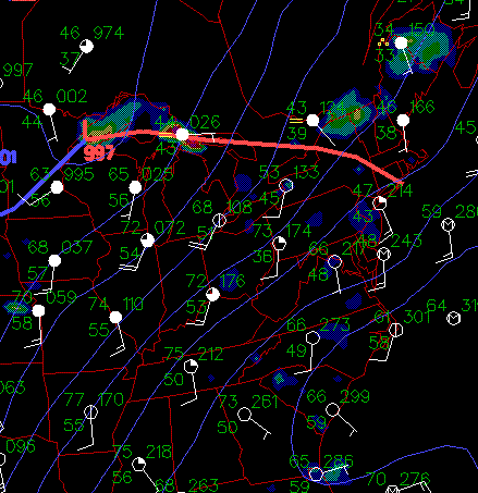
These maps includes the NY wintering grounds where Eagle #F42 was reported as of March 25. Notice the placement of the red line (warm front) on this map on Thursday evening, March 26. So Thursday night, near #F42 the temperature was also 42!! Light rain showers were the rule in the area. |
 |
By Thursday night measurable rainfall was to the north of the eagles. |
 |
Warm temperatures early Thursday evening showed how warm it was over Ohio, West Virginia, and Virginia. That same warm sunny weather was on the way to New York! |
 |
Here's an interesting map. The blue lines show the winds ushering in thicker, warmer air into the area. Meteorologists call this 'warm air advection'. |
 |
A few thousand feet in the atmosphere the winds are from the southwest also! |
 |
So....the warm front fell over #F42 at the crack of dawn. Temperatures breaking 50 and the sun coming out are what F42 awakes to. It's time to: "Get up and GO"! Notice the winds are 15 knots (17 miles per hour from the south-southeast (SSE)! |
 |
Friday morning's satellite image shows clear to partly cloudy clouds in the region, and NO CLOUDS to the south and west means it's going to dry out some more! |
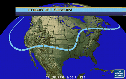 |
The jet stream shows that any cool air is trapped way to the North, so it won't be getting cold anytime soon. The blue line North of New York shows the general boundary between the cold air and warm air in the atmosphere. South of the line winds may be light at the surface! |
 |
The surface map for Friday shows high pressure takes over the East. The circulation around the HIGH pressure, and southerly and westerly winds would be felt all day. |
 |
And that continued into the weekend, where temperatures in the Lower Hudson Valley-the old campground for our feathered folk-were near 80 for Saturday and Sunday the 28th and 29th. |
 |
Where will she go? Right through Tuesday, March 31st, #F42 has run of the coast! The information shows light winds for days and sunshine for days. It will be great to see where she ends up. The steering winds might not be too much to overcome. |
Glen Schuster, Meteorologist
Josh Danziger, Student Meteorologist
U.S. Satellite Laboratory
Tarrytown, NY
Technology for Remote Sensing in Schools
satlab@ns.computer.net