


Manatee Migration Update: March 5, 2003
Today's Report Includes:
- Latest Map and Satellite Data
- Grab Your Boarding Pass and Climb In! Challenge Question #13 & #14
- Why are Aerial Manatee Count Numbers Controversial? Challenge Question #15
- An Unsung Hero: Ranger Wayne Receives Award
- How Can You Tell One Manatee From Another?
- It's Your Turn: You Make the Call! (Roll Call That Is) Challenge Question # 16
- Field Notes from Cathy Beck
- Manatees Are on the Move! Discussion of CQ #8 & #9
- Manatee Interrupted: Discussion of CQ #10
- Raise Your Flipper: Discussion of CQ #11
- Why Does the Daily Manatee Count Change: Discussion of CQ #12
- Coming in the Next Report
Latest Map and Satellite Data
|
|
| Latest All Manatees Migration
Map |

Link to Latest Data and Maps:
(Courtesy
of U.S. Geological Survey's Sirenia Project)
- Data & Individual Map for Actual
- Data & Individual Map for Anna
- Data & Individual Map for Chuck
- Data & Individual Map for Gulliver
- Data & Individual Map for Santina
- Data & Individual Map for Thumper
- Data & Individual Map for Tipper
- Data Only for All Manatees--Printer-friendly Format
Grab Your Boarding Pass and Climb In!
Have you ever wondered what it would be like to ride in the airplane for one of the aerial manatee counts? How high would you fly? What kind of plane would you use? What would you watch for? And what possible connection is there between Rice Krispies and doing aerial manatee counts?
Now you can find out, and get a real feel for flying in the plane too. Then come back and answer the Challenge Questions below.
 |
Challenge Question #13:
"Looking down from an airplane, what objects in the water might be mistaken for a manatee? Think about living things, and non-living things too (both natural and manmade.)"Challenge Question #14:
"If Airborne Ackerman cannot actually see a manatee swimming in muddy water from his airplane, how could he still know that one is there? What other signs would he look for?"
(To respond to these Challenge Questions, please follow the instructions below.)
In the next report, Dr. Ackerman will challenge you to make an aerial count from photographs. Will you be able to find all of the manatees that his trained expert eye can find?
Why are Aerial Manatee Count Numbers Controversial?
|
|
| A View From Above |

There are many factors that can influence the count each year, and weather conditions on the day of the count can severely affect the number of manatees counted, both up and down. Because of this and other important factors to consider, population researchers recognize that the annual synoptic survey is not a complete measure of manatee population or population trends. As Dr. Ackerman said recently, "The counts reflect the number of manatees they are able to locate each year based on weather conditions, nothing more."
Nevertheless, every year the manatee data numbers get used by different groups to support different ideas about the current status of the Endangered Manatee population in Florida.
We've summarized the high manatee count numbers since 1991, and also what two different groups say those count numbers actually mean in "Be Careful with Numbers." Take a look at this summary, and then see if you can answer the Challenge Question that follows:
- Be Careful with Numbers
Challenge Question #15:
"What conclusions can you draw about the size of the Florida manatee population from the fact that this year's count is higher than last year? What if this year's count had been lower than last year?"
(To respond to this question, please follow the instructions
below.)
An Unsung Hero: Ranger Wayne Receives Award
|
|
| Congratulations
|

Thank you Ranger Wayne for your tireless dedication in helping to conserve
and protect the endangered manatee (and educate us humans too!)
You're a true hero.
How Do You Tell One Manatee From Another?
|
|
| Cathy viewing the "MIPS" database |

But wait! How do Manatee scientists like Ranger Wayne and Cathy Beck identify individual Manatees? How do they tell one from another?
Get the basics on what to look for and then come back for your turn trying to identify some Blue Spring Manatees below:
It's Your Turn: You Make the Call! (Roll Call That Is)
|
|
| Can you tell me who's in the Run today? |

Let's start by taking a look at the question you'll need to answer:
Manatee A is ___________
Challenge Question # 16:
"Who do you see in the Run today? Can you identify each Manatee in the photos?
Manatee B is ___________
Manatee C is ___________
Manatee D is ___________
Manatee E is ___________
Manatee F is ___________"
But Wait! Before you paddle up the Run, you'll need a few essential supplies to help you identify the Manatees. Be sure you have these: Your Key, the Sketch Worksheet, the Scar Sheet, and a few simple instructions to follow (oh, and your life jacket too, of course).
- Essential Supplies (i.e.
Instructions on How to do This Activity)
| Who's in the Run Today? |
||
|
|
|
|
|
|
|
|


(To respond to this question, please follow the instructions below.)
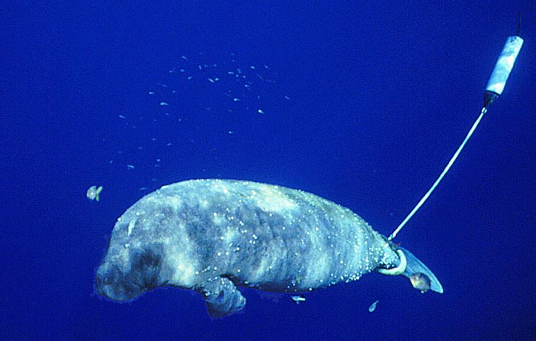
Field Notes from Cathy Beck
|
|
| Seagrass and Mangrove
leaves anyone? |

And Jim Reid returned from the field, and reported that as of last Friday all is well with the remaining tagged manatees. I say "remaining" tagged manatees because now we finally know that Chuck no longer has his tag. Jim reported that a FWS colleague recovered Chuck's tag late on 2/21/03 at 25.926N, 81.507W, just off of Faka Union Canal. Jim had a chance to examine the tag. The tether was broken at the weak link, possibly after it became entangled in mangrove roots, which were all around the area where it was found. Letting the manatee break free from his tag like this is exactly what a weak link is designed to do. It prevents a manatee from getting stuck or hurt if the tag or tether gets caught in something.
In the prior week, our manatees were spending more time in the outer grassbeds as the temperature continued to warm. Jim reported that the shallow bays with abundant seagrass are quick to warm and are especially attractive to manatees after cool spells. Anna and Actual spent some time visiting the grass beds near Panther and Round Keys, Gulliver was still favoring the Fakahatchee Bay and East River area, and Thumper apparently is content with the grassbeds near Chokoloskee Pass. As for Tipper, we are wondering if she will ever come south again?
I'll let you know if we learn anything more about Chuck. In the meantime, I've included the latest tracking data for all the manatees, and I'll be back again soon with more news on our Manatees. Bye for now.
Cathy Beck
Sirenia Project
Gainesville, FL
Teacher Tips: NEW Reading and Writing Connections AND Instructional Strategies
Manatees Are on the Move! Discussion of CQ #8 & #9
In answer to Challenge Question #8, the two manatees that made the long northward migrations were Anna (who swam from Whitewater Bay back to POI) and Tipper (who swam from Whitewater Bay to POI and then farther north all the way up to Gasparilla Sound near Ft. Meyers.) The weather maps reveal that water temperatures had warmed significantly, which takes away the risk of cold temperature illness for the manatees, and allows them to swim to other areas again.
For Challenge Question #9, these classes figured out that warm temperatures and food are what took the manatees offshore:
- "The
manatees have been visiting offshore areas because the water is getting
warmer there. They are finding food, mates, and resting areas."
The Grade 7A students--Chelsea, Helena, Michele, Tasha, Nick,
Dana, Hythum, and Nina from Iselin Middle School
- "Manatees
are moving offshore because the temperature is warmer and there is more
food." Group 10 from St. John Greek Orthodox
School.
- "I believe that the manatees are looking for warm water and food." Group 8, St. John Greek Orthodox School
Great observations everyone! In fact, the manatees are finding sea grass beds offshore. And just like you on the first warm days of spring, the warmer temperatures allow the manatees to mover farther and easier than in the colder temperatures.
Manatee Interrupted: Discussion of CQ #10
|
|
| Credit: USGS, BRD, Sirenia Project |
"Maybe Gulliver went too far away from the signal tracker and then came back, or it might have been a wire shortage. Chuck could have gotten eaten by an alligator or he gotten stuck in Red Tide and died. He also could have wondered off like Gulliver." Nicole and Emily, St. John Greek Orthodox Day School
Lots of factors can interrupt satellite tracking signals, including alligators biting and damaging the tags, and other injuries to the manatee and its tag. For Gulliver and Chuck, Cathy Beck explained several different possibilities. "The quality of the location plotted by the satellite varies, depending on whether the Manatee (actually the antenna) is at the surface when the satellite passes--the antenna must reach the surface in order to broadcast the signal to the satellite. Also, data quality can be affected when there are a lot of structures or vegetation that may interfere with the signal."
"For Chuck, we discovered his tag had broken away, and it was found in heavy vegetation in the mangrove roots where signals can be interfered with. For Gulliver, signals may also have been interrupted if he had been in a heavily vegetated area for a period of time; or he just might have been on the bottom resting in deep water with his tag submerged when the satellite passes occurred, causing a lack of high quality locality information being transmitted. His signals have resumed."
Raise Your Flipper When Your Name is Called: Discussion of CQ #11:
A) Ranger Wayne reported that Georgia took someone's jeans off the dock in the Swimming Area. Transect numbers 9, 10 and 11 are the location of the Swimming Area (also known as the "scene of the crime" where Georgia took the jeans.)
B) On November 18, Ranger Wayne observed most of the manatees located between the Canoe Basin Barrier (CB) and Transect 2. For Transect 17, Ranger Wayne knew a manatee had been there because he observed Manatee feces there.
C) By December 12, the dark water from the St. John's River had pushed farther up into the Run beyond Transect #1, whereas on November 18 the dark water had just barely gone beyond the Canoe Basin Area border. And by December 12, the manatees are located further into the Run, with significant numbers of manatees in Transects 2, 3 and 4, and even in Transects 11-13 too.
D) On December 27, the temperature of the River water was now only 14.5 degrees Celsius, as compared with temperatures of 17.5 and 18.7 on December 12 and November 18 respectively. By December 27, the dark river water has pushed even farther into the Run, reaching beyond Transect #3 almost to Transect #4.
E) By January 27, the River water temperature is now only 11.0 degrees Celsius, the dark water has reached all the way to Transect #4, and so the manatees are now seen all the way up in the Boil (Transect # 18 and 19), an area they were not yet in back on November 18 or December 12.
|
|
|
|
|
| November 18 |
December 12 |
December 27 |
January 27 |


Why Does the Daily Manatee Count Change: Discussion of CQ #12
In this question, we asked "Why do you think the number of manatees in the Blue Spring Run changes each day? Can you see any patterns or trends in the data below that explain the reason(s) for the changing number of manatees?"
Listen to Ranger Wayne explain the answer Audio Clip (.aif format, 1521 K) (.wav format, 1521 K) |
 |
Ranger Wayne explained that it all relates to the River temperature:
"The magic number is in the river, its 68 degrees F. When it gets down to 68 as the cold weather comes on, the manatees start coming in. The lower it gets below 68, the more manatees you're going to see."
Coming in the Next Report:
- The Latest Migration News and Maps
- The Latest from Blue Spring
- We're Going to the Movies--Can You identify a Moving Manatee?
- Can You Count Manatees from the Air?
- Try the Dark Water Experiment
- Manatee Adaptations
- Next Generation Tracking Transmitters
How to Respond to Today's Challenge Questions:
IMPORTANT: Answer only ONE question in each e-mail message.
1. Address an e-mail message to: jn-challenge-manatee@learner.org
2. In the Subject Line of your message write: Challenge
Question # 13(OR #14 OR #15 OR #16)
3. In the body of EACH message, give your answer to ONE of the questions
above.
The Next Manatee Migration Update Will Be Posted on
March 19, 2003
Copyright 2003 Journey North. All
Rights Reserved.
Please send all questions, comments, and suggestions to our feedback form
![]()
![]()
![]()
![]()
![]()
![]()
