


Monarch Butterfly Migration Update: October 24, 2003
Today’s Update Includes:
- Highlights From the Migration Trail
- Noticias del avance de la migración en México
- Watching and Waiting at the Mexican Sanctuaries
- Earth From Space: Looking Down at the Migration Pathway
- Can You Follow the Monarchs' Trail?
- The United States of Mexico: Challenge Question #13
Highlights From the Migration Trail
 |
| Click Map to Read Highlights Along the Migration Trail |
- On October 22, the first real pulse of migrants was observed on Florida's Gulf Coast, according to the migration-tracking team at St Marks Wildlife Refuge.
- Hundreds of monarchs were flying west along two beaches in Alabama on October 19.
- On the 18th, while standing on a barrier island about 10 miles off the coast of Mississippi, an observer noted "monarchs, carried by a strong north wind, were going by about 2 per minute."
- Carole Jordan reported high migration activity from several places in both Louisiana and Mississippi throughout much of the week.
- On the Texas coast, Harlen Aschen says the migration continues after the passage of each front.
In all, 177 migration reports were recorded this week from northern and mid-latitude states, as well as from southern latitudes. However, while monarchs are still spread across a wide range, their numbers are now concentrated in the south.
 |
 |
 |
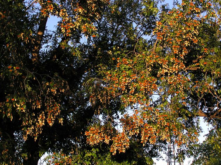
| Monarchs
Rest as They Travel Through Texas Photos courtesy of Paul Cherubini |
||
 |
 |
 |
Noticias del avance de la migración en México
Monarch sightings are starting to pour in from Nuevo Leon and Coahuila, Mexico. Thanks to Rocio Treviño for sending the news from her post in Saltillo, Coahuila. Those who speak Spanish can hear the migration greeted with awe and wonder in the language of Mexico. Last week, a teacher and students counted 300 monarchs in a half hour, another person saw "clouds of monarchs all over our city." Rocio herself counted 1,230 monarchs in 35 minutes, while driving her car at the same time! She reports:
“Estimados amigos: El pico de la migración se encuentra desde hace varios días en los Estados de Coahuila y Nuevo León, durante una semana han volado por estos estados varios millones de mariposas. Pero como ha sucedido en los otoños anteriores, el buen clima imperante nos ha impedido disfrutar más de ellas. Se levantan temprano y en poco tiempo alcanzan grandes alturas. También es notable la presencia de muchas especies de mariposas que anteriormente no eran tan comunes en esta época del año. Sigan disfrutando del paso del cortejo real.”
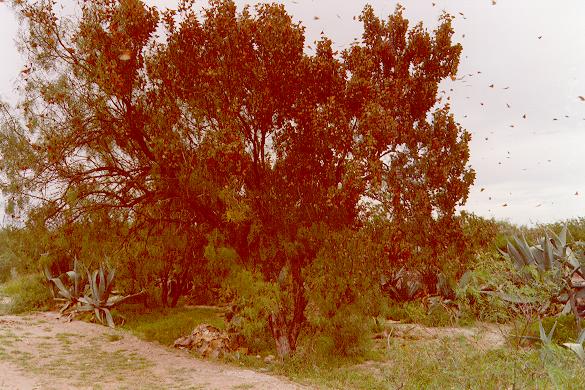
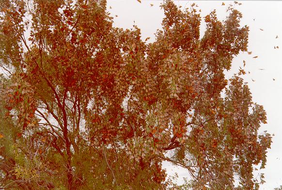
| Monarchs
Traveling Through Coahuila, Mexico Photos courtesy of Roció Treviño (1997 photos) |
||
 |
 |
 |
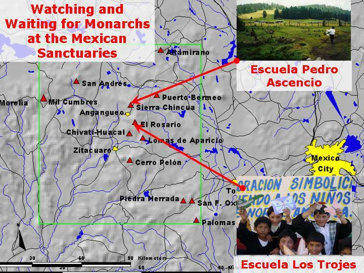 |
German Medina, who’s coordinating reports from schools in the sanctuary area, is not surprised the monarchs didn’t arrive last week. The weather has been bad in the sanctuary area, he says, but he hopes the first arrivals might appear when the weather clears. Stay tuned! What’s your prediction? Measure the distance between the sanctuaries and today’s southernmost reports.
Earth From Space: Looking Down at the Migration Pathway
A treat this week: NASA’s "Visible Earth" website is full of beautiful images of our planet. We found a spectacular, cloudless view of Mexico. It's so large and detailed that the very mountain tops the monarchs are now approaching can be seen.
"The map is incredible," said Dr. Bill Calvert as he confirmed that landmarks on the ground matched his description of the migration route. "It's really cool."
Now, Dr. Calvert is a calm and articulate person who chooses his words carefully. Clearly, even he was excited. Enjoy the view. It's so realistic it almost produces a sense of vertigo. Read on...
The Monarchs' Migration Pathway Through Mexico
Can You Follow the Monarchs' Trail?
Contributed by Dr. Bill Calvert
 |
Once in Mexico, the butterflies join the Sierra Madre Oriental Mountains in the states of Coahuila and Nuevo Leon. The butterflies seem to turn their direction to follow the mountain chain, heading south/southeast.
The Sierra Madre Oriental forms a great elongated massif that stands in the path of the easterly winds that predominate at this time of year. In short, as easterly winds blow, the butterflies get a 'lift' from these winds. The air rises over the east-facing mountain slopes of the multiple ranges of the Sierra Madre Oriental. When the butterflies fly through the inner montane valleys of the Sierra Madres, this rising air makes flight much easier. During late afternoon, after a day when no or few butterflies have been seen, they often quite suddenly "fall out" of the sky and begin to nectar or to form their evening roosts.
The pathway in Mexico extends from the U.S. border near Ciudad Acuna, to Monclava, then Santa Catarina. (Santa Catarina, west of Monterrey and east of Saltillo, is famous for monarchs.) The monarchs seem to follow the mountain crest/valleys especially in area between Monterrey and Linares, Nuevo Leon. This is a major monarch highway, through all the little towns like Galeana, Neuvo Leon and Iturbide, Neuvo Leon.
| Northern
Mexico from NASA
Visible Earth (Click Image to Enlarge) |
 |
They continue moving to the south-southeast, hugging the mountains to the west of Ciudad Victoria, Tamaulipas. Near Jaumave, Tamaulipas they pass through an amazing portal into the inner montane valleys called the Novilla Canyon. When south of Cuidad de Maiz, San Luis Potosi there's a pass where monarchs go through at exceedingly high rates, probably thousands per minute.
When the butterflies reach deep, central Mexico they get thicker and thicker and are easier to find as they are concentrated by the Sierra Madre Oriental along which they fly. These mountains seem to focus the migration, and direct it towards the overwintering sites located in the Transvolcanic Belt of central Mexico (19 N, -100 W).
Looking at the map, what happens next is just so delightfully confusing! They've been traveling slightly to the east when following the Sierra Madre Oriental. But then they come to the region surrounding Jalpan, Queretaro, that's called the Sierra Gorda and they head south. I think this is what's most incredible--this change in direction in the mountains. They don't seem to have any clear ranges to follow, yet they seem to make this turn. (The Sierra Gorda region is highly dissected by rivers and valleys are not aligned in a north/south direction like the Sierra Madres.)
We just don't know where the monarchs are when they go through the Sierra Gorda. It's a thinly populated, mountainous area and so not many people see them. You can see monarchs in Jalpan, Queretaro, then again at Queretaro, Queretaro and Tequisquiapan, Queretaro.
 |
At last they start to hit the Transvolcanic Mountains-- Amealco, Guanajuato, Coroneo, Guanajuato, then finally Contepec, Michoacan which is the northernmost over-wintering site.
Amazingly, the over-wintering area the monarchs have to hit is very, very narrow. This is an area only is 1.1 degrees wide, in longitude. The western-most side is at “Mil Cumbres” (-100.8 W, a large wiggle in the road between Ciudad Hidalgo and Morelia) and the eastern-most side is the Nevado de Toluca (-99.7 W). This means that, assuming that monarchs cannot “home” and correct the consequences of a miss, those migrants flying in from the north must strike the Transvolcanic Belt somewhere within this 1.1 degree window to find the overwintering sites!
The United States of Mexico: Challenge Question #13
Did you know that Mexico is divided into states? Which states does the migration cross? Read Dr. Calvert's description of the migration route in northern Mexico carefully, then see if you can answer these questions:
Challenge Question #13:
"How many states does Mexico have? According to Dr. Calvert, which states do the monarchs travel through?"
How to Respond to Today's Challenge Question
1. Address an e-mail message to: jn-challenge-monarch@learner.org
2. In the Subject Line of the message write: Challenge Question #13
3. In the body of the message, answer the question above.
The Next Monarch Migration Update Will Be Posted on October 31, 2003.
Copyright
2003 Journey North. All Rights Reserved.
Please send all questions, comments, and suggestions to our feedback form
![]()
![]()
![]()
![]()
![]()
![]()
