USFWS


![]()
Manatee Migration Update: April 1, 1998
Today's Report Contains:
- North With The Spring! Latest Manatee Satellite Information and Challenge Question # 11
- As the Crow Flies...Challenge Question # 12
- April Fool's Data? Discussion of Challenge Question # 9
- My, What A Lovely Transmitter You Have!
- "Tag" A Manatee By The Tail
- Welcome Spring Warmth
- Ranger Wayne's Roll Call And Responses to Challenge Question # 10
- Today's Satellite Migration Data
- How to Respond to Today's Challenge Questions
North With The Spring! Latest Satellite Information And Challenge Question # 11
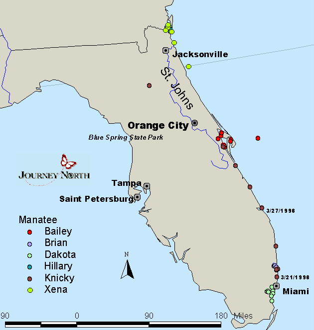
"Well, we finally have a true 'move'!", exclaimed biologist Cathy Beck. "Knicky is heading north with the beautiful spring weather we are now having. She is in the Jensen Beach area (north of the St. Lucie Inlet) this morning."
- Using Knicky's daily location data below for March 21-27, calculate the distance
in degrees that she traveled north each day. (For example, Knicky traveled .024 degrees
north from 03/23 to 03/24: 26.577 - 25.553 = .024 degrees)
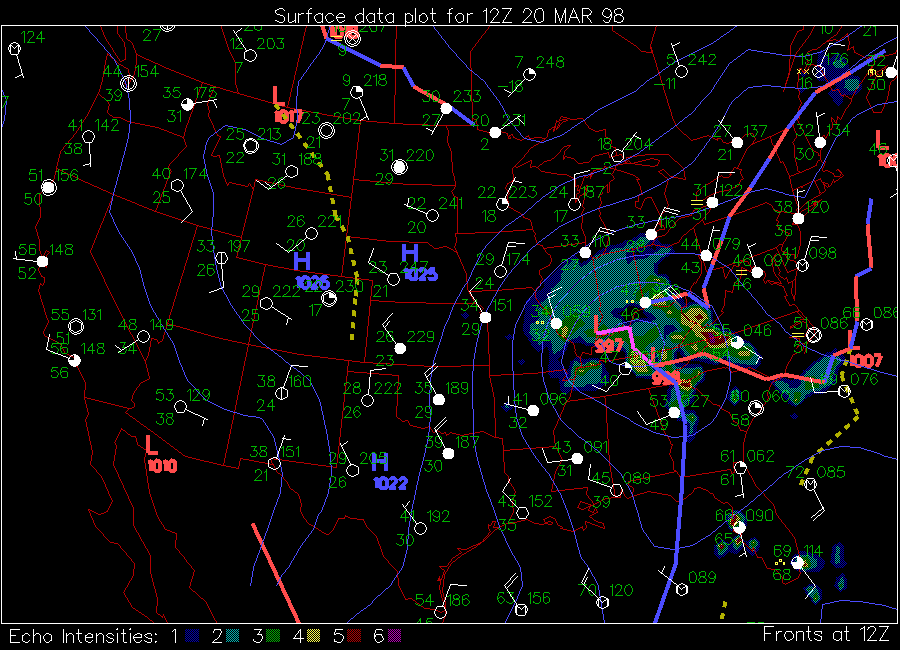
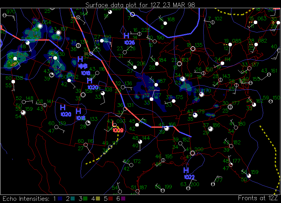
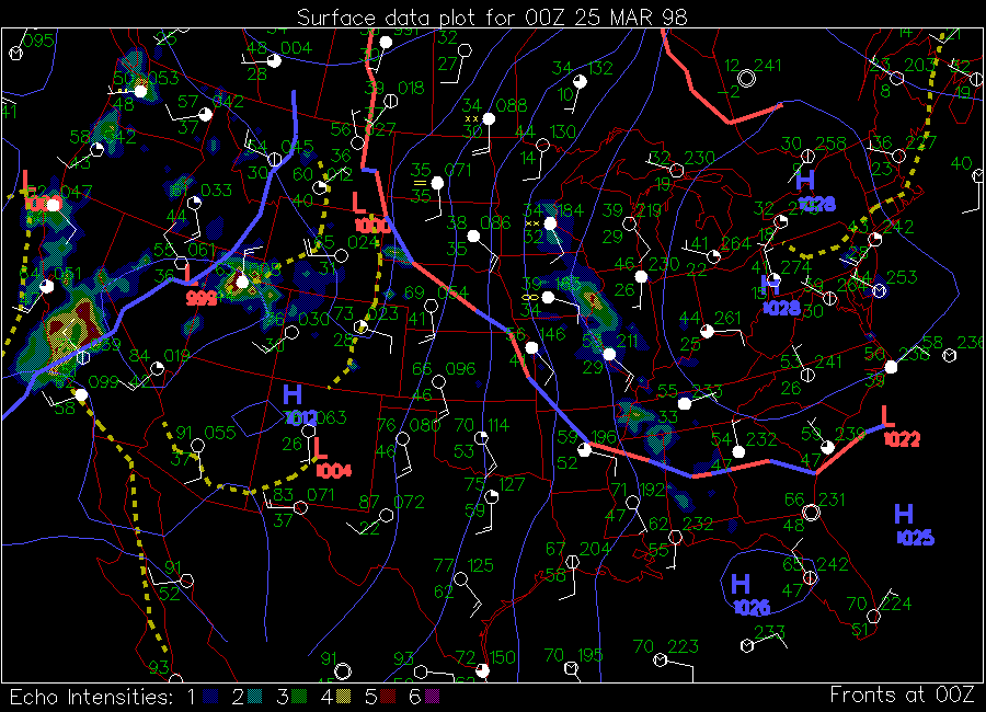
- Then, take a look at the Florida satellite temperature images below and see if you can answer this challenge question:
Challenge Question # 11:
"Which days did Knicky move the farthest? Which days did she move the least?
Can you find any correlation between the distance Knicky traveled on these days and the temperatures shown on the satellite images?Knicky's Location Data March 21-27:
Date
Lat
Long
03/21/98
25.941
-80.141
03/22/98
26.366
-80.075
03/23/98
26.553
-80.049
03/24/98
26.577
-80.063
03/25/98
26.837
-80.045
03/26/98
27.031
-80.094
03/27/98
27.233
-80.212
Florida Satellite Temperature Images:


March 20
March 21
March 23
March 25
Click on each image to see full map

(To respond
to this Challenge Question, follow the instructions at the end of this report.)
As the Crow Flies...Challenge Question # 12
|
|
|
Click on map to enlarge |
Challenge Question # 12
"How far did Knicky travel between March 21 and March 27, 1998?
Give your answer in both kilometers and miles."
HINT: Check out the "How
Far Is It ?" website that lets you find the distance between two places,
using latitude and longitude. The distance is calculated "as the crow flies",
says the site--but it works for manatees too. It even gives you a map showing the
location of both places.
(Follow the instructions
at the end of this report on How to Answer this Challenge Question.)
April Fool's Data? Discussion of Challenge Question # 9
Challenge Question #9 was an early April Fool's question, which asked where Knicky was located on March 6, 1998 (lat 29.756, long -82.094). If you plotted the data carefully on a map you saw that Knicky appeared to be far inland in Gainesville, FL. Or was it just part of her? As Cathy Beck explains, the data was accurate--but only for Knicky's transmitter, not Knicky.
"Jim retagged Knicky, but I didn't know that. I was in meetings most all day on the 5th and 6th. That's why she made a little trip to Gainesville - actually her old tag did. No wonder we got a very good quality location - her tag was about 20 feet away from me! Her new tag number is just one digit away from the old and I didn't notice. She hasn't moved much; her location on 03/06/98 should have read 25.943,-80.127"
|
|
|
Photo credit: James Reid |
Have you ever wondered HOW these transmitters are used--what do the transmitters look like, how do the scientists attach them to the manatees, what kind of radio signals are sent out, how long do the transmitters last, and what happens if the transmitter gets caught in something Well, read on for some insights about the transmitters.
Floating Radios
The radio transmitters are contained inside of floating plastic cylinders about 39 cm long and 9 cm in diameter. The cylinders have a 20 cm wire antenna on the top of them, and every cylinder is color-coded with large identifying letters and engravings on them. Our thanks to Jim Reid and Bob Bonde of the Sirenia Project for the photo of the manatee tracking devices, which can be seen in today's report on the WWW. Each cylinder actually has two different transmitters inside it, one called a VHF transmitter which sends specific radio frequency signals to scientists in the field using a portable receiver, and another called a Platform Transmitter Terminal or "PTT" that sends out location signals to an orbiting satellite. Typically, the PTT will send from two to six different location points for each tagged manatee every day.
According to Cathy Beck, inaccurate satellite tracking data can occur however, for several different reasons. "The quality of the location plotted by the satellite varies, depending on whether the manatee (actually the antenna) is at the surface when the satellite passes, or whether there are a lot of structures or vegetation that may interfere with the signal."
|
|
| Click on Image to See The Transmitter--Courtesy of USGS Sirenia Project |
Journey North students tracking the migration of the Bald Eagle know that the eagle wears a "backpack" transmitter. Manatee transmitters, on the other hand, are attached with a "peduncle belt" and a "nylon tether, " which you can see in the diagram to the right.
The belt goes around the manatee just in front of its tail, in an area called its "peduncle", and the tether is a stiff nylon rod (about 10 mm in diameter and 130 to 200 cm long) that connects the belt to the transmitter. Each tether has a "weak link" built into it, which will break and allow the manatee to swim free if the tether or transmitter ever become snagged on something such as a dock, a boat, thick vegetation, or even a hungry alligator!! Yes, that's right, scientists have reported seeing an alligator pull a transmitter off a manatee, and also have found alligator teeth marks on other transmitters.
Tag A Manatee By The Tail
There are several methods the scientists use to capture and "tag" manatees with radio transmitters. Many are captured with nets after the scientists lure them with fresh water running from a garden hose; some are tagged after they had been captured for rehabilitation (like Dakota); and finally, some are actually cooperative and can being tagged by scientists with snorkels who gently swim near the manatees and put a belt around their tails. As you'll read below, Bailey is not in the "cooperative" category, at least not lately.
Catch Me If You Can!
Cathy Beck has reported that "Bailey is back in the Banana River," and making things very interesting for biologists Bob Bonde and Jim Reid. "Bob tried to retag Bailey last week and Jim the week before, without any luck. His tag needs to be changed, but he is very wily and alert." Cathy added that two other biologists were going to try their luck retagging Bailey, but it was decided that once he loses this tag, he really doesn't need to carry a new one since he's doing so well and seems to have adapted successfully to the wild.
Welcome Spring Warmth
The warm spring weather in Florida is a very welcome change this year. Since the time of our last Manatee Update, cold weather is suspected as a possible contributory cause in two more manatee deaths in northeast Florida/southeast Georgia, including the recent death of Hillary, who we had been tracking this year. As Cathy Beck said, "It has been a crazy winter, and a very bad one for the manatees in NE Florida and SE Georgia. From Jan 1 through March 20, 1998 fifteen (15) manatees are known to have died in this area. From Jan through March of 1997, two (2) had died in this region."
Ranger Wayne's Blue Spring Roll Call
|
|
|
Ranger Wayne Hartley |

Last week Ranger Wayne announced the birth of Phyllis' calf, "Phire", and we asked "How do you think manatee calves are named?". Students really got "phired up" with answers to this challenge question!
"We think they use the first few letters of the mother's name." Nanuet School District
esgrade4g@BARRMS1.LHRIC.ORG
"They are named by the first letter of the mother's name."
Erin Scacchetti and Emma Wilson
Hudson Falls Middle School
Ms. Lobb's period 4 class
Hudson Falls, NY
mkrantz@mum.neric.org
Both answers were correct, according to Ranger Wayne, who tells us that a Manatee calf at Blue Spring is given a name that is "usually something reflecting the first letter or sound of the mother's name." ("Phire" was actually named by Ranger Wayne's wife.)
Ranger Wayne also sent in his latest Roll Call data. Remember to look for correlations between the river water temperatures and the number of manatees counted at Blue Spring. Also, with the warmer spring weather on its way, how much longer do you think Ranger Wayne will still have manatees visiting Blue Spring?
Roll Call Chart
|
Date |
Air Temp (C) |
River Temp (C) |
Run Temp. (C) |
# of Manatees |
|
03/20/98 |
17-25 |
19.2 |
nt |
9 |
|
03/22/98 |
6-27 |
18.2 |
nt |
16 |
|
03/26/98 |
6-30 |
19.4 |
nt |
15 |
|
03/28/98 |
14-30 |
20.5 |
22.5 |
3 |
Today's Satellite Migration Data
(Courtesy of U.S. Geological Survey's Sirenia Project)
- Go to Satellite Data Table for Dakota
- Go to Satellite Data Table for Knicky
- Go to Satellite Data Table for Bailey
- See above for Hillary information
How To Respond to Today's Challenge Questions:
Please answer ONLY ONE question in each e-mail message:
1. Address an E-mail message to: jn-challenge-manatee@learner.org
2. IMPORTANT: In the Subject Line of your message write: Challenge Question # 11 (OR # 12 )
3. In the body of the EACH message, give your answer to ONE of the
questions above.
The FINAL Manatee Update will Be Posted on April 15, 1998
Copyright 1998 Journey North. All Rights Reserved.