 |
 |
 |
 |
 |
 |
 |
Manatee Migration Update: March 17, 1999
Today's Report Includes:
- Where's Ivan? Dicussion of CQ #6
- My, What A Lovely "Transmitter" You Have!
- Solving the "Mo" Mystery: Discussion of CQ #7
- By Land, Air and Sea! Discussion of CQ #8
- Life's A Challenge! CQ #10
- Ranger Wayne's Roll Call
Where's Ivan? Dicussion of CQ #6
|
|

"Jim Reid and Susan Butler finally caught up with Dmitra and Ivan's transmitters on Wed. 2/17 in New Port Richey! Both tags had been hit by a boat! Ivan's transmitter was completely sheared off, leaving only the nose cone attached to the end of the tether. Dmitra's tag was also struck. Jim said that when he saw Ivan's tag he had to hesitate before looking down. Thankfully, neither manatee was injured! Jim was able to get the remains of the old tags off both animals and attach a new transmitter to Dmitra's belt; but they swam off together before he could retag Ivan. We hope to retag Ivan soon!"
There's still no data from Ivan, but you'll notice data for three new manatees
including "Brian" (a male who many of you may remember from last year),
"Xoshi" (a female), and "Crystal", a female calf who's still
with her mother. Like Ivan, Crystal may also separate from her mom this spring, so
keep watching for more of Cathy's "calf" news.
Today's Satellite Migration Data
(Courtesy
of U.S. Geological Survey's Sirenia Project)
- Go to Satellite Data Table for Knicky
- Go to Satellite Data Table for Jeb
- Go to Satellite Data Table for Dmitra
- Go to Satellite Data Table for Ivan
- Go to Satellite Data Table for Brian
- Go to Satellite Data Table for Xoshi
- Go to Satellite Data Table for Crystal
My, What A Lovely "Transmitter" You Have!
|
|
|
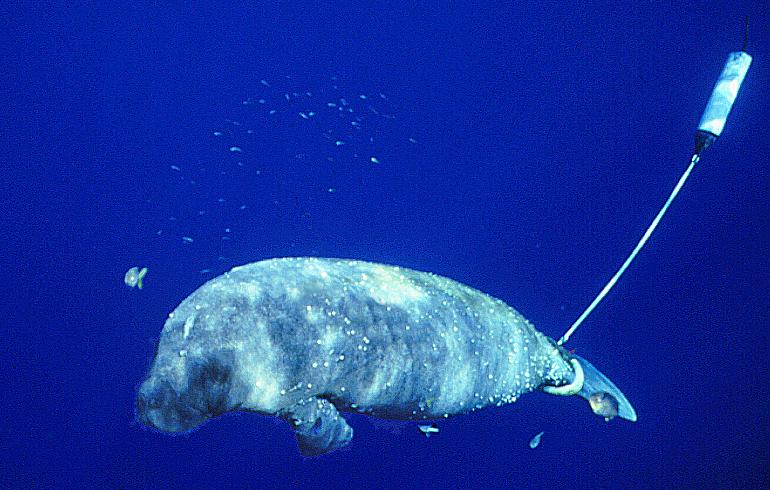
Manatee with transmitter |
Floating Radios
|
|
|
Illustration of a Manatee transmitter |
According to Cathy Beck, satellite tracking data can be inaccurate or be interrupted for several different reasons. "The quality of the location plotted by the satellite varies, depending on whether the manatee (actually the antenna) is at the surface when the satellite passes--the antenna must reach the surface in order to broadcast the signal to the satellite. Also, data quality can be affected when there are a lot of structures or vegetation that may interfere with the signal."
Backpacks, Peduncle Belts, Tethers and Alligators?!
|
|
|
Gator! |

Solving the "Mo" Mystery: Discussion of CQ #7
|
|
|
Mo |
Mo's long distance journey came as somewhat of a surprise. "He was released at Crystal River and stayed there for about 2 weeks, with lots of 'location' data. Then for the next 3-4 weeks we only got 1-2 locations as he traveled south. He then popped up in the Dry Tortugas with some good locations, where Jim was able to catch up with him. Actually that simplifies the story. Besides 'location' information we receive data on 'activity'. This information indicated it was attached to the manatee, rather than rolling around in a boat (perhaps picked up by a fisherman)", said Cathy Beck. When the location data were finally received again, Mo was well outside normal manatee habitat. In fact, Mo is the first tagged manatee ever documented to move so far offshore!
|
|
|
Jim Reid |

Mo was far from food and fresh water, and Jim traveled to the Dry Tortugas islands to lead the rescue effort. With invaluable help from the National Park Service Dry Tortugas staff and a Sea World Orlando field crew, Mo was found drifting about 20 miles west of the Dry Tortugas in waters that were 175 deep. He had lost 180 pounds from his release weight of 735 pounds, and was dehydrated and malnourished. Mo approached the Sea World rescue boat, and was captured with a hoop net. Thankfully, he is back at Sea World, and is expected to make a full recovery--whew!
Challenge Question #9:
"From what you've learned in today's report about transmitters, why do you think Mo's 'location' data were interrupted for 3-4 weeks?
(To respond
to this question, please follow the instructions below.)
By Land, Air and Sea! Discussion of CQ #8
|
|
|
Dr. Bruce Ackerman |

Just what do the lower manatee counts mean? Are there actually fewer manatees than in 1996 and 1997, or do other factors affect the counts? Mrs. Sgalippi's 4th grade manatee group in Horsham, PA suggested one factor that could affect the count:
"We think that it is because in the past years it has been colder than this year so less Manatees are coming" (MSgalipp@Hatboro-Horsham.org)
According to Dr. Ackerman, "biologists are confident that the lower count
does not signal a sudden decrease in the size of the population, which we still estimate
to be at least 2,400." Instead, the lower counts were the result of warmer weather
this year. "Because this has been an unusually warm winter, it has been difficult
to find the kind of colder weather that results in the highest counts."
Researchers normally want a prolonged cold front followed by a clear, windless day
to conduct the best count. The colder water temperatures cause the manatees to seek
out warm water sites, and the clear day encourages them to float, making them easier
to count. Before the first count this year, there had been a long warm spell and
"manatees were still migrating to their wintering sites", Dr. Ackerman
said. By the second count, "a series of cold fronts in mid-February dropped
the water temperatures enough to attract many manatees into their warm water aggregation
sites."
As you can see, the number of manatees from one count to the next can be the result
of many things, and a count can vary by several hundred manatees simply due to weather
conditions. Be careful with numbers. They are very exact--but sometimes their meaning
may not be so clear.
Dr. Ackerman hopes to do another aerial survey to help refine the estimate of the
minimum size of the population, so stay tuned for more "in-flight" information.
Life's A Challenge!
The manatee population counts remind us of how difficult it is for a manatee to survive. Think about the many causes of disease and death that manatees face in the wild, and then try to answer the Challenge Question below. Before answering, you may want to review this Web site:
Challenge Question # 10
"What are all the risks that cause disease or death to manatees. Which one's are "natural causes", and which ones are human-related?"
(To respond
to this question, please follow the instructions below.)
Ranger Wayne's Roll Call
|
|
|
Ranger Wayne Hartley |

|
Date |
Air Temp High(C) |
Air Temp Low(C) |
River Temp (C) |
Run Temp. (C) |
# of Manatees |
|
03/02/99 |
26 |
9 |
18.1 |
nt |
36 |
|
03/05/99 |
30 |
2.5 |
17.4 |
22.5 |
65 |
|
03/06/99 |
27 |
9 |
16.9 |
nt |
50 |
|
03/07/99 |
30.5 |
11 |
17.8 |
nt |
25 |
|
03/10/99 |
28 |
8 |
18.6 |
22.5 |
15 |
|
03/12/99 |
30 |
7 |
19.9 |
nt |
25 |
How to Respond to Today's Challenge Questions:
Please answer ONLY ONE question in each e-mail message!:
1. Address an E-mail message to: jn-challenge-manatee@learner.org
2. IMPORTANT: In the Subject Line of your message write: Challenge Question # 9 (OR # 10)
3. In the body of the EACH message, give your answer to ONE of the questions above.
The Next Manatee Migration Update will Be Posted on March 31, 1999.
Copyright 1999 Journey North. All Rights Reserved. Please send all questions, comments, and suggestions to our feedback form
 |
|
|
|
|
|
|
