 |
 |
 |
 |
 |
 |
 |
Manatee Migration Update: March 21, 2001
Today's Report Includes:
- Field Notes From Cathy Beck: Challenge Question #18
- As the Crow Flies (or as Surfer Swims!)
- Challenge Questions #19 & #20
- Today's Satellite Migration Data and Map
- Like Playing In Snow Without A Jacket: Challenge Question #21
- Try This!
- Ranger's Roll Call Continues: Challenge Question #22
- Ask the Expert Answers Now Available!
- Dean's Daring Duty: Discussion of CQ #14
- No Backpacks Here! How Does a Manatee Wear a Transmitter?
- Side By Side: Discussion of CQ #15
- Abiding the Tides: Discussion of CQ #16
- Discussion of CQ #17
- Sea Cow Conversions: Discussion of CQ #12
Field Notes From Cathy Beck
 "Hello
Again Students!
"Hello
Again Students!"This week we are planning another manatee capture. Its part our current study near Ten Thousand Islands. Stay tuned, we may have a new batch of manatees to follow very soon!
"Jim, Bob, Susan, and Dean all left Monday afternoon for the capture trip. They're headed for Port of the Islands (POI), the same area where they captured Addison, Grace, Megan, Nina, and Santina earlier this year. While they're gone, I'll be 'holding down the fort' here, but I'll keep you posted!
Challenge Question #18:
"Why do you think the scientists want to capture and tag more manatees for this same study? Also, is there any different characteristic you'd want in the new manatees? Why? (Think about what you already know about Addison, Grace, Megan, Nina, Santina and Surfer.)
(To respond to this question, please follow the instructions below.)
"On Thursday, Jim and Dean were in the field again. They were following Grace,
who is still using the Ten Thousand Islands habitat. Jim and Dean were intending
to retrieve the GPS tag that Dean attached earlier. (Learn how Dean did this daring
duty below--Discussion of CQ #14).
"We're really eager to get Grace's GPS tag back, so we can download the data.
We expect it will let us determine Grace's movements on a fine scale. I hope to have
the GPS data downloaded and plotted by the next report, so I can let you know of
any interesting observations.
"Megan continues to move between the seagrass beds of Ten Thousand Islands
and POI; she has also traveled out near Cape Romano. Santina seems to be exploring
the sites in Chokoloskee Bay. And both Nina and Addison are staying in the Marco
area.
"By the next report, we may be introducing some more manatees so stay tuned.
In the meantime, take a look at the latest satellite tracking data below.
Today's Satellite Migration Data
(Courtesy of U.S. Geological Survey's Sirenia Project)
- Go to Satellite Data Table for Addison
- Go to Satellite Data Table for Grace
- Go to Satellite Data Table for Megan
- Go to Satellite Data Table for Nina
- Go to Satellite Data Table for Santina
- Go to Satellite Data Table for Surfer
As the Crow Flies (Or as Surfer Swims!)
"Meanwhile, Surfer continues to use the bays and rivers to the south. Don't be surprised if her 3/12 location appears to plot on land (depending on the resolution of your map), but there are small rivers that she is accessing!
Challenge Question #19:
'Plot Surfer's locations between 03/07 and 03/15. Which date(s) was Surfer:
a) On the coast?
b) Swimming from the coast inland?
c) Furthest south in the inland rivers?
d) Moving back to the coast?'
Challenge Question #20:
'What is the total distance Surfer traveled between 03/07 and 03/15? (Use the on-line Distance Calculator to estimate the distance 'as the crow flies' that she swam between each of the datapoints, then add the distances together and tell us her total distance traveled.')"
(To respond
to these questions, please follow the instructions below.)
Cathy Beck
Sirenia
Project
Gainesville, FL
Like Playing In The Snow Without A Jacket
In the last report, Dr. Ackerman noted that the long cold spell that contributed to the high manatee count this year might also have a negative impact on the manatee population. "Similar cold conditions have resulted in higher than normal manatee mortality due to cold stress," he noted.
Challenge Question #21:
"Why do you think a large marine mammal like a Manatee cannot tolerate cold water when another large marine mammal like a Whale can?"
(To respond
to this question, please follow the instructions below.)
Try This!
If you'd like to try something extra, you can test "first-hand" if cold
feels different to a manatee than it does to a whale. Try these experiments from
Manatee expert Bob Bonde and whale expert Ann Smrcina. This may be a bit messy, but
the experience is worth it! If you do either of the experiments, tell us how it went
in your answer!
Ranger's Canoe Count Continues: Challenge Question #22
|
|
|
Ranger Wayne Hartley |

Ranger Wayne has sent the data for his latest Roll Calls, along with a challenge for you.
Challenge Question #22:
"During my recent Roll Calls, I counted 13, 24, 27, and 37 manatees in the Run on four different days. Study my temperature data below. Can you match the number of manatees I counted with the correct date I counted them? Put your answer in the blanks in the last column"
|
Date |
Air Temp Low(C) |
Air Temp High(C) |
River Temp (C) |
Run Temp. (C) |
# of Manatees |
| 03/05 |
10 |
32 |
22 |
nt |
4 |
| 03/07 |
4 |
21 |
19 |
nt |
? |
| 03/09 |
3 |
24 |
18 |
22.5 |
? |
| 03/10 |
13 |
26 |
20 |
nt |
? |
| 03/11 |
9.5 |
20 |
19.5 |
nt |
? |
| 03/13 |
13 |
32.5 |
21 |
nt |
4 |
| 03/16 |
15 |
32 |
22.5 |
22.9 |
0 |
(To respond
to this question, please follow the instructions below.)
Ranger Wayne Hartley
Blue Spring State Park
Ask the Expert Answers Now Available!
Take a look at what inquiring minds wanted to know! Manatee Expert, Nancy Sadusky from Save the Manatee Club, has sent in her answers to your Ask the Expert questions.
Dean's Daring Duty: Discussion of CQ #14
|
|

The daring team of Dan, Mark, Alex and Joe from Iselin Middle School put themselves in Dean's place and offered their advice:
"If we were Dean and we had to get a GPS tag on Grace, we would have to make her calm enough to let us do so. First, we would go out in a rowboat, not a motor boat, because the latter could injure or scare her. Then, we would simply get close enough to net her and to tag her. Grace may react scared, at first. The thing that might endanger Dean when tagging a Manatee is being tipped out of the boat by the scared animal. Dean should try to proceed as calmly and quietly as possible." Iselin Middle School/grade 7, Susan Eckstein (susamel@verizonmail.com)
Cathy Beck explains how Dean achieved his daring duty:
"To attach a GPS tag to Grace's existing tag assembly, Dean first located Grace in a finger canal at POI. He quietly followed her in his boat as she moved out into the Faka Union Canal. To get closer, Dean entered the water himself to swim toward Grace. This may sound easy, but it's quite an accomplishment. Dean had to be very careful to attach the tag without startling her. If she were to quickly and forcefully buck away, Dean could be endangering himself. After all, Grace weighed 970 pounds (when tagged), and manatees can swim very fast in a short burst--up to 20 mph! So Dean swam VERY quietly, to approach Grace close enough to attach the GPS tag without alarming her. Mission accomplished! Oh, and one more thing. . . since Dean was swimming in the water, he also had to keep an eye out for something else--alligators!"
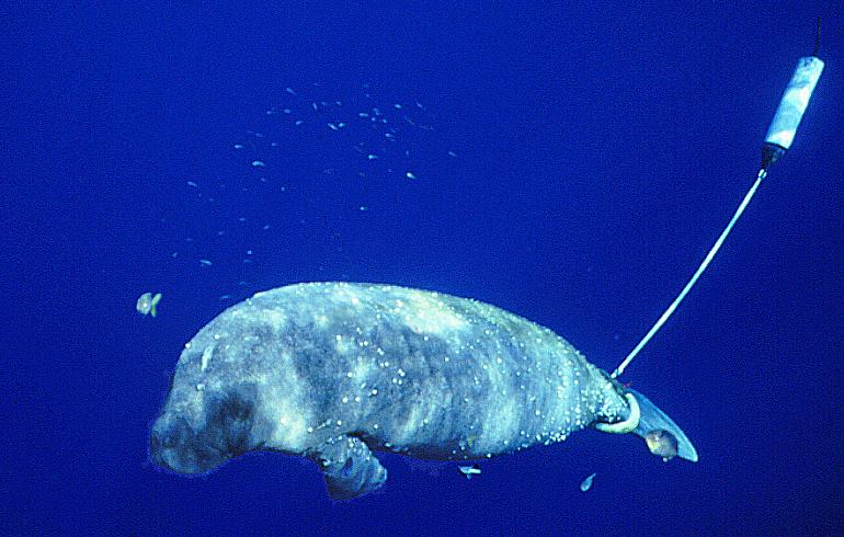
No Backpacks Here! How Does a Manatee Wear a Transmitter?
 |
Side By Side: Discussion of CQ #15
In this Challenge Question, we asked "If the scientists hadn't received a public sighting of Addison and Nina on March 1, what would they have been able to determine from the data alone about their locations that day? Can you tell on which dates they were closest to each other?"
With the data alone, the scientists would not have known that on March 1 Nina and Addison were right next to each other. This is because the data only provide a March 1 datapoint for Nina, and do not provide a March 1 location datapoint for Addison.
However, Allan from Ms. Quinn's Class in Tampa, FL did a nice job explaining that scientists could at least see from the data that Addison and Nina had been somewhat close together over several days:
"They could determine that they have been so close to each other all the time. This date is when they were the closest: Addison 3/2/01 25.977N - 81.702W and Nina 3/2/01 25.979N - 81.713 W." Allan 5 th, Ms. Quinn's Class, Saint John's Greek Orthodox Day School (sgreek1@tampabay.rr.com)
Abiding the Tides: Discussion of CQ #16
|
|

"We believe that the answers for challenge question #16 are as follows:
a) The highest tide for this day is 4.14 feet.
b) The lowest tide for the day is -0.9 feet.
c) The water level rose 5.04 feet.
d) The river level increased 3.41 feet.
e) The best time for a manatee to leave the river would be at 22:29 EST. (iselin5@injersey.infi.net)
Nice job! And now, can you take Part (d) a step further to determine the amount
that the tide rose PER HOUR between 16:54 and 22:29?
The Iselin Team correctly determined that the river tide level increased 3.41 feet
between 16:54 and 22:29. To get the hourly rate of change, get out your calculators
and follow along with these steps:
1. Determine the number of hours and minutes between 16:54 and 22:29 = 5 hrs, 35 minutes
2. Determine that 5 hrs, 35 minutes is equal to 5.583 hours (35 minutes divided by .6 = .583 hours plus 5 hours = 5.583 hours)
3. Divide 3.41 feet by 5.583 hours = 0.6107827 ft per hour or 7.329 inches per hour (12 inches [one foot] divided by 0.6107827 = 7.329 inches)4. The tide rose 7.39 inches per hour!
Abiding the Tides: Discussion of CQ #17
In Challenge Question #17 we asked what other factors, in addition to tides, can affect water level or depth on or near a seashore, and we asked you to think of things both above and below the water surface.
The Astronomical Causes of Tides
To begin, it is important to understand that the high tides are caused primarily by the gravitational forces of the moon, which are referred to as "astronomical" forces. This gravitational force of the moon "pulls" the Earth's ocean waters toward the moon, into a sort of "bulge", on whatever side of the Earth is facing the moon. A second high tide "bulge" occurs at the same time on the opposite side of the Earth, due to centrifugal forces from the rotating earth, which "fling" the ocean waters outward on that side. Meanwhile, low tide areas are occurring in the waters on the two other sides of the Earth, because the waters of those areas have been dragged away to fill the high tide bulge areas. Further lessons and diagrams of these forces are available on the WWW:
The Non-Astronomical Influence on Tides
But there are non-astronomical forces that affect the water level or depth too. For
instance, above the water surface level, local wind, rain, and freshwater runoff
from the land can impact the water level.
Below the water surface, the shape or "topography" of the ocean floor can
influence the depth of the water. For instance, think of walking in the water at
a beach. As you walk further out, the water is deeper. But the change in depth is
not due the water surface level rising as you go out. Instead, it is caused by the
fact that the shape of the ocean floor itself slopes down or deeper as you walk out.
Sea Cow Conversions: Discussion of CQ #12
We've made the conversions from centimeters into inches (cm x 0.394 = inches), and pounds into kilograms (pounds x 0.454 = kilograms). Compare your answers and see how you did:
|
Name |
Length(cm) |
Inches |
Weight(lbs.) |
Kilograms |
| Megan |
319 cm |
125.686 in. |
1,085 lbs. |
492.15 kg |
| Addison |
248 cm |
97.712 in |
680 lbs. |
308.44 kg |
| Nina |
270 cm |
106.380 in |
885 lbs. |
401.43 kg |
| Santina |
285 cm |
112.290 in |
990 lbs. |
449.06 kg |
| Grace |
286 cm |
112.684 in |
970 lbs. |
439.98 kg |
How to Respond to Today's Challenge Questions
IMPORTANT: Answer only ONE question in each e-mail message.
1. Address an E-mail message to: jn-challenge-manatee@learner.org
2. IMPORTANT: In the Subject
Line of your message write: Challenge Question #18 (OR #19, OR #20
OR #21 OR #22)
3. In the body of the EACH message, give your answer to ONE of the questions above.
The Next Manatee Migration Update will Be Posted on April 4, 2001
Copyright 2001 Journey North. All Rights Reserved. Please send all questions, comments, and suggestions to our feedback form
 |
|
|
|
|
|
|
