Where in the World?
Introduction to Latitude and Longitude
Overview
Students play a grid-based game and devise clues to help classmates find
locations on the globe. In doing so, they come to recognize the value
of using latitude and longitude for identifying locations.
Background
Students
participating in Mystery Class must understand geographic location. Every
spot on the Earth can be described in both relative and absolute terms.
In our everyday lives, we think mainly about relative location: Where places
are in relation to other places. Is it close by? Can I get there from here?
What else is nearby?
In Journey North, absolute location is important. Using a mathematical grid
system (in this case, latitude and longitude), any spot on earth can be
identified with just two numbers. In order to location mystery classes students should know
how to use latitude and longitude with ease. This lesson lays the groundwork
by helping students recognize the value of using a grid system for finding
locations.
Laying
the Groundwork
Write these sentences on the board:
- My house is close to the mall.
- John's house is on the corner of Maple Street and Elm Avenue.
- My cousin's house is in a small Texas town named Beeville.
Ask, Which of these statements would be most useful in helping you find the house that's mentioned? Have them explain their thinking. Accept their responses and encourage discussion. Finally, invite the class to explore different ways of describing locations.
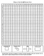
Exploration: Hidden Animals
- Invite
the class to play an animal variation of the "Battleship"
game. Divide the class into pairs and give each student a copy of the
Where in the World? Animal Grid.
- Ask partner
#1 to hide the four migratory animals somewhere on the grid, but not
to show the grid to his or her partner. Partner #2 must then guess coordinates
(e.g.,
C,8) to locate the animals. Partner #1 should respond "yes"
or "no" to each guess to indicate whether
any part of an animal touches those coordinates. Partner #2 should
use a blank
grid to mark responses and narrow down the possible locations
for each animal. Partners should switch roles when one has uncovered
all the animals.
- Ask the
class, Was
the
grid/coodinate
system
helpful
in
finding
the animals? Why or why not?
If students are unfamiliar with latitude/longitude lines on maps, explore a map together. Ask them to describe things they notice about it. If they don't point out the lines running across the page (latitude) and lines running up and down (longitude), ask them if they see any type of grid. Ask, Why do you think these lines are drawn on many maps? Discuss the way the lines are numbered and share as much detail as is appropriate for your grade range.
Making Connections — Discussion and Journaling Questions
- How is the grid you used in the animal hiding game similar to latitude and longitude lines?
- What was challenging about finding the hidden animals?
Time Materials |
|
| Hidden
Animals Animal Grid |
|
 |
|
© 1997 – 2024 Journey North. All rights reserved.