The
Location of the Monarch Overwintering Sites in Mexico
Why
is This Place So Special for Monarchs?
![]()
1)
Use Maps to Make Predictions
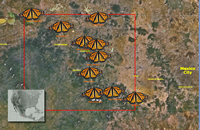
a) "Before" Map:
Help the students
get oriented. Ask, what are we looking at? Where is this place? What does
the red rectangle mean? What is green; brown? Point to features and ask
questions. Make sure the students can see the
topography of the region (mountains, valleys, etc.).
- Predict: Where might the monarchs form their colonies? Have students give a fact or observation to back up their thinking.
b)
"After" Map
When you "mouse
over" the map, the location of the 12 monarchs colonies appears.
Move the mouse back and forth several times so you can inspect the landscape
underneath each butterfly/colony. (Try
it!) Wait for the students to notice that the monarch colonies are
on mountains. Ask, How did the locations compare to your predictions?
Were monarch colonies missing in places you thought they would be? What
questions does the map raise?
2)
Gain Perspective & Consider
Conservation Implications
North America's monarchs
spend the winter--together--in an astonishingly small region. The butterflies
that overwinter in Mexico are the primary seed stock of all future migratory
monarchs.
- Emphasize size: Notice how small the over-wintering region is, and how little of the area has suitable habitat for monarchs! By mid-winter the monarchs at each colony will form such tight clusters that the area of the entire population will cover only 5-50 acres (2-20 hectares). (See details about winter population measurements.)
- Make a personal connection: On a map, measure out an area the same size as the monarch's over-wintering region. (See example to right. Assume the sides of the red rectangle are 70 miles in length.) Superimpose a region of the same size on map that includes your hometown. Then add the location of each of the monarch colonies. Measure the relative distance from your hometown to the colonies. Students will see familiar town names and gain a sense of the distances.
- Consider threats: Ask, What are the risks of having the monarchs over-winter in one small place/region? (fire, disease, storms, human destruction, forest longevity, etc.) Are there benefits? Explore these ideas and issues when Journey North starts again in February.
3)
Science Concepts: What is a Microclimate?
Look at the pictures on the page, "Why
is this place so special for monarchs?" List some of the important
variables in the microclimate of the monarch's winter habitat. The
microclimate of the monarch's forest is key to the butterflies'
survival. Help students understand this concept. Take them outside to
find local examples of microclimates. Feel the differences between
sun/shade, wind/calm, south/north slopes, damp/dry, etc. Measure the
differences between air temperature of paved, grassy, wooded areas,
etc. (See related lesson: Exploring
Microclimates.)
4)
Science and History
Scientists did not know the location of the monarch overwintering region
until National Geographic announced the discovery in 1976. See: A
Discovery Tale
Journaling Prompt
- Where would you look to find a yet undiscovered monarch colony? What would you look for and why? Describe an imaginary expedition. Write a field journal about your trip. (Remind students that the monarch's winter home is a remote region; perhaps scientists simply haven't found other sites.)
5)
Join us in February and March!
Journey North publishes weekly updates every winter while the monarchs
are in Mexico. The updates begin in February and lead up to monarchs'
spring migration in March. Join us for a "guided tour" of the
monarch's winter
habitat.
<< Back to: "The Location of the Monarch Overwintering Sites in Mexico: Why is This Place So Special for Monarchs?"
Map of the Monarch Overwintering Sites in Mexico
If the monarchs were near Chicago...
Monarchs
and Microclimates
A "microclimate" is the localized climate of a small place.
Find local examples of microclimates on your school ground


